
Dr Yasjka Meijer | Monitoring Greenhouse Gas Emissions from Space: The Copernicus CO2M Mission
Atmospheric concentrations of carbon dioxide (CO2) and methane (CH4) have been steadily rising due to human activities, contributing to global climate change. Dr Yasjka Meijer from the European Space Agency is responsible for the objectives and requirements of the Copernicus Anthropogenic Carbon Dioxide Monitoring (CO2M) mission – a constellation of satellites that will enable the monitoring of anthropogenic greenhouse gas emissions from space with unprecedented accuracy and detail. This groundbreaking mission aims to support international efforts to reduce emissions and combat climate change.
Why Monitoring Greenhouse Gases Matters
Greenhouse gases like CO2 and CH4 absorb heat in Earth’s atmosphere, causing global temperatures to rise. The atmosphere (functioning similarly to glass in a greenhouse) is sufficiently transparent to allow short-wave radiation from the Sun but the outgoing long-wave radiation from the Earth is absorbed by greenhouse gases, causing temperatures to rise. CO2 concentrations have increased by over 40% since pre-industrial times, primarily due to fossil fuel combustion, cement production, and land use changes. CH4, while less abundant, is an even more potent greenhouse gas.
The 2015 Paris Agreement aims to limit global warming to well below 2°C above pre-industrial levels. Meeting this target requires substantial reductions in anthropogenic greenhouse gas emissions. However, large uncertainties still exist in our understanding of emission sources and trends at national, regional and local scales. More accurate, timely and comprehensive monitoring is essential for guiding mitigation efforts.
Satellites offer a unique vantage point to track atmospheric CO2 and CH4 globally. While existing missions like NASA’s OCO-2 and GOSAT focus mainly on natural carbon cycle processes and have a research focus, there is a growing need for a dedicated system to operationally monitor anthropogenic emissions. This is where the Copernicus CO2M mission comes in.
The Copernicus CO2M Mission – Observing Our Earth
The European Commission, European Space Agency, European Organisation for the Exploitation of Meteorological Satellites, and European Centre for Medium-Range Weather Forecasts are jointly developing a Greenhouse Gas Monitoring and Verification Support capacity as part of Europe’s Copernicus Earth observation programme, which relies as one of its key pillars on data from the CO2M mission.
CO2M will consist of a constellation of initially two to later three identical satellites in polar low-Earth orbit. The satellites will carry a suite of innovative instruments to measure atmospheric CO2 and CH4 concentrations with high precision (0.7 ppm for CO2, 10 ppb for CH4) at a spatial resolution of 4 km2 over a wide swath of 250 km. This will enable near-daily revisits over most of the globe. CO2M will be the first mission optimised to enable the quantification of anthropogenic CO2 emissions and will provide its data to a unique monitoring system to support transparent tracking of emissions and to provide actionable information for climate policy.
Seeing Through the Haze with Multi-Angle Polarimetry
One of the key challenges in measuring greenhouse gases from space is accounting for the effects of aerosols and clouds, which can scatter light and introduce errors in gas retrievals. CO2M tackles this using an innovative multi-angle polarimeter (MAP) instrument alongside its CO2 and CH4 spectrometers. The MAP instrument will provide critical aerosol property information for accurately translating the measured spectra into greenhouse gas concentrations. By observing the same scene from multiple angles and measuring the polarisation state of backscattered sunlight, the MAP can better constrain aerosol properties and improve the accuracy of greenhouse gas measurements.
Pinpointing Fossil Fuel Emissions with NO2
Another novel aspect of CO2M is its ability to measure nitrogen dioxide (NO2) in addition to CO2 and CH4. NO2 is co-emitted during high-temperature fossil fuel combustion and can serve as a marker for anthropogenic CO2 emissions. Plumes of NO2 are easier to distinguish from space as NO2 background concentrations are relatively low, which is not the case for CO2. NO2 observations add a powerful constraint to distinguish between anthropogenic and biospheric CO2 fluxes.
Used together, CO2 and NO2 measurements can help pinpoint emissions from cities, power plants, and other major sources. In a simulation study, synthetic CO2M observations of NO2 alongside CO2 significantly improved the detection and quantification of CO2 plumes from large point sources. This synergistic use of co-located trace gas measurements is a promising avenue to enhance CO2M’s monitoring capabilities.

Credit: Image: ESA/Mlabspace
Seeing the Forest for the Trees with Auxiliary Imager
Even with its advanced instruments, CO2M needs to avoid taking measurements contaminated by clouds, which can severely degrade the quality of greenhouse gas retrievals. For this purpose, the satellites will carry an auxiliary cloud imager. The imager will provide high-resolution cloud detection to identify clear-sky scenes suitable for greenhouse gas retrievals. It will also detect cirrus clouds and help screen out measurements affected by scattering from high-altitude ice crystals.
By optimising its observational coverage, CO2M aims to maximise the number of useful measurements obtained over emission hotspots and other areas of interest for monitoring. Advanced algorithms will intelligently sift through the data to extract the most valuable information for quantifying anthropogenic emissions.
Complementing Bottom-Up Emission Inventories
Once in orbit, CO2M will collect millions of observations of atmospheric CO2 and CH4 concentrations each day. But to translate those concentrations into information on the location, magnitude and trends in emissions, the measurements must be combined with models of atmospheric transport using a technique called inverse modelling. By assimilating CO2M data into atmospheric transport models, the 4D distribution of CO2 and CH4 sources and sinks at the Earth’s surface can be inferred. These top-down emission estimates will provide an independent check on the bottom-up inventories reported by countries.
Traditionally, anthropogenic emissions are estimated using bottom-up methods that combine activity data (such as fuel consumption) with emission factors. While essential, these inventories can have large uncertainties due to gaps or inaccuracies in the underlying data, and come with a significant time delay. Satellite observations offer a complementary top-down view that is more complete, nearly instantaneous, and consistent across countries. By combining CO2M data with ground-based measurements and emission inventories using inverse modelling, scientists will produce a more robust, harmonised picture of greenhouse gas emissions around the world. This will support the Paris Agreement’s framework for tracking progress with regular ‘global stocktakes’ of collective emission reduction efforts and will also enable policymakers with actionable information.
Observing System Simulation Experiments
To evaluate the expected performance of CO2M and guide its development, Dr Yasjka Meijer and colleagues are conducting observing system simulation experiments (OSSEs). In an OSSE, a reference ‘true’ atmosphere is first simulated in detail. Synthetic satellite observations are then generated from this simulation, incorporating realistic instrument errors and sampling limitations.
OSSEs provide a framework to test the impact of different mission configurations and observational scenarios on the ability to estimate emissions. They help optimise the mission design and ensure it will meet its ambitious monitoring objectives. Recent OSSEs have demonstrated the benefit of increasing the number of satellites in the CO2M constellation. The OSSEs also highlight the importance of sustained, long-term monitoring. Due to day-to-day variability in weather and sampling conditions, multiple years of observations are needed to detect realistic changes in emissions at the scale of countries or regions. By providing operational continuity, CO2M will enable the tracking of emission trends over time.
Empowering Climate Action from a New Vantage Point
The Copernicus CO2M mission is on track for launch in 2026. Once operational, this pioneering constellation of European satellites will bring greenhouse gas monitoring into a new era. Armed with this unique monitoring capability, policymakers and stakeholders worldwide will have a powerful tool to track emission reduction pledges, assess the effectiveness of mitigation measures, and identify areas for further action. At the same time, scientists will gain unprecedented insights into the carbon cycle and its perturbation by human activities. By providing decision-makers with timely and actionable information that they need, this mission will guide us on the path to a more sustainable, climate-friendly future.
SHARE
DOWNLOAD E-BOOK

REFERENCE
https://doi.org/10.33548/SCIENTIA1211
MEET THE RESEARCHER

Dr Yasjka Meijer
European Space Agency (ESA), Earth and Mission Sciences Division, Noordwijk, The Netherlands
Dr Yasjka Meijer obtained his Master’s degree in Physics and Astronomy from Vrije Universiteit Amsterdam in 1997 and his PhD in Atmospheric Physics from the Technical University of Eindhoven in 2005. He has over 25 years of experience in remote-sensing techniques and atmospheric research. Since 2007, Dr Meijer has worked at the European Space Agency, first as an Atmospheric Scientist and now as the Copernicus CO2M Mission Scientist. In this role, he is responsible for the mission requirements of the pioneering Copernicus anthropogenic CO2 monitoring mission.
Dr Meijer is a member of key international advisory groups and leads an international team of space agencies’ experts on greenhouse gas monitoring. His expertise is helping shape the next generation of satellites and to advance our understanding of the Earth’s atmosphere and climate.
CONTACT
E: yasjka.meijer@esa.int
W: https://www.linkedin.com/in/yasjka-meijer-087919/
KEY COLLABORATORS
ECMWF, EUMETSAT, JAXA, NASA, and various European research institutes
European Commission CO2 Task Force
Joint Committee on Earth Observation Satellites (CEOS) and Coordination Group on Meteorological Satellites (CGMS) Greenhouse Gas Task Team
World Meteorological Organization (WMO) Advisory Group on the Global Greenhouse Gas Watch (G3W)
FUNDING
The CO2M Mission is jointly funded by the European Space Agency and the European Commission within the European Copernicus Programme.
FURTHER READING
YJ Meijer, et al., Editorial: Anthropogenic emission monitoring with the Copernicus CO2 monitoring mission, Frontiers in Remote Sensing, 2023, 4, 1217568. DOI: https://doi.org/10.3389/frsen.2023.1217568
YJ Meijer, et al., Roadmap for a coordinated implementation of carbon dioxide and methane monitoring from space. Joint CEOS-CGMS Working Group on Climate, Greenhouse Gas Task Team Report, 2024. Available at: https://ceos.org/document_management/Publications/Publications-and-Key-Documents/Atmosphere/CEOS_CGMS_GHG_Roadmap_Issue_2_V1.0_FINAL.pdf
ESA (Y Meijer, Mission Scientist), Copernicus CO2 Monitoring Mission Requirements Document (MRD), 2020. Available at: https://esamultimedia.esa.int/docs/EarthObservation/CO2M_MRD_v3.0_20201001_Issued.pdf
G Janssens-Maenhout, et al., Toward an Operational Anthropogenic CO2 Emissions Monitoring and Verification Support Capacity, Bulletin of the American Meteorological Society, 2020, 101(8), E1439–E1451. DOI: https://doi.org/10.1175/BAMS-D-19-0017.1
![]()
REPUBLISH OUR ARTICLES
We encourage all formats of sharing and republishing of our articles. Whether you want to host on your website, publication or blog, we welcome this. Find out more
Creative Commons Licence (CC BY 4.0)
This work is licensed under a Creative Commons Attribution 4.0 International License. 
What does this mean?
Share: You can copy and redistribute the material in any medium or format
Adapt: You can change, and build upon the material for any purpose, even commercially.
Credit: You must give appropriate credit, provide a link to the license, and indicate if changes were made.
SUBSCRIBE NOW
Follow Us
MORE ARTICLES YOU MAY LIKE
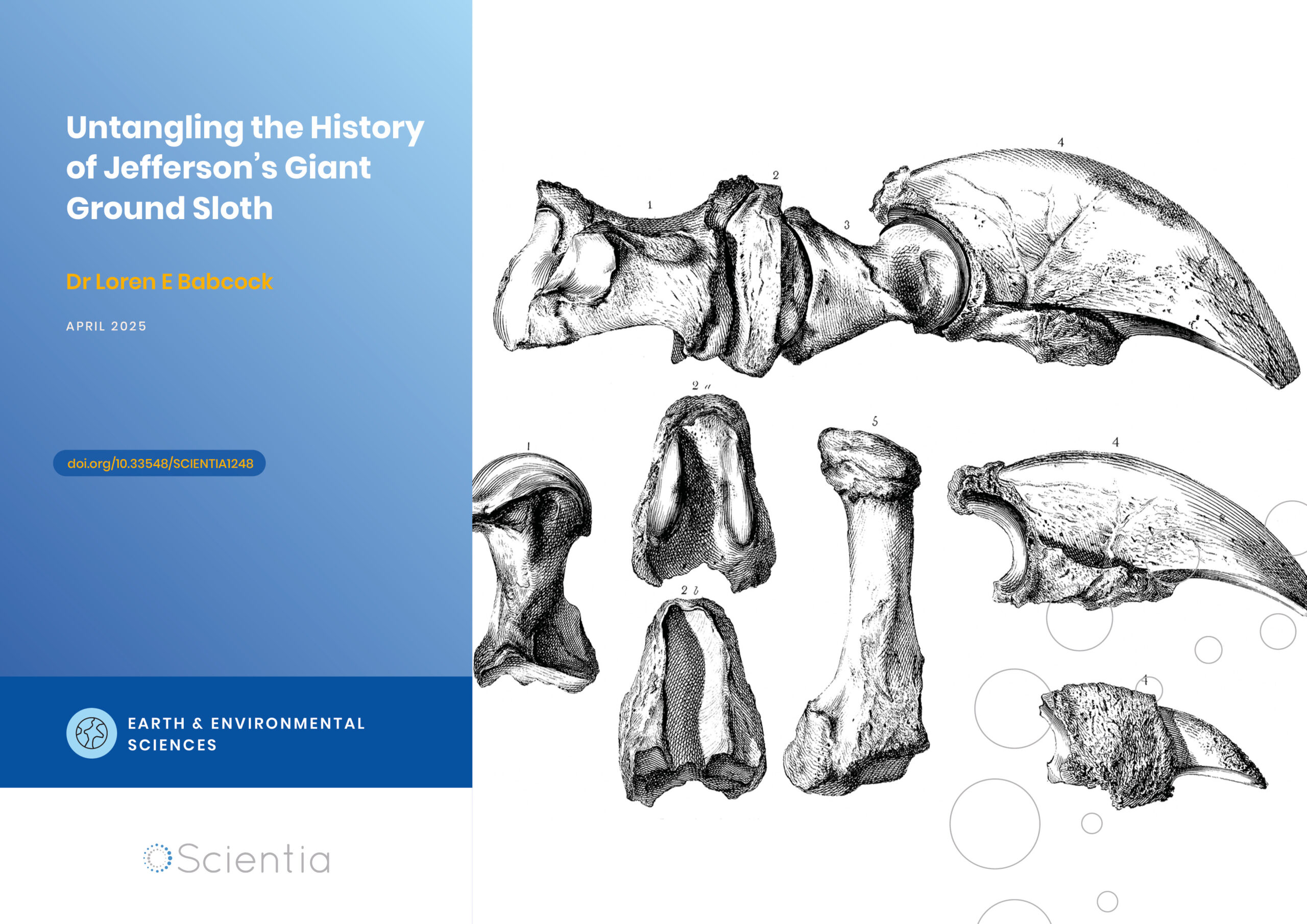
Dr Loren Babcock | Untangling the History of Jefferson’s Giant Ground Sloth
In the spring of 1796, workers mining saltpetre in a western Virginia cave unearthed several unusual bones. This would launch the scientific study of extinct animals in North America and connect one of America’s founding fathers to the early development of palaeontology. Some of these mysterious bones eventually made their way to future US President Thomas Jefferson at his Monticello estate. Dr Loren Babcock from The Ohio State University’s School of Earth Sciences has conducted an extensive review of the complex naming history of this iconic extinct animal. His research untangles over 200 years of inconsistent scientific terminology and establishes the definitive nomenclatural history of what would become known as Megalonyx jeffersonii.
Dr Mojtaba Enayati | Turning Trash into Treasure: Recycling PET Waste with Catalysts from PET Labels
Plastic pollution has become a critical environmental problem, with polyethylene terephthalate (PET) plastic widely used in food and beverage packaging being a major contributor. Dr Mojtaba Enayati from Troy University’s Center for Materials and Manufacturing Sciences (CMMS) is leading innovative research aimed at utilising the labels from PET water bottles as an environmentally friendly and cost-effective catalyst for chemically recycling PET waste into valuable monomers and other value-added materials. This innovative work provides an elegant solution for recycling PET by sourcing key components from the PET bottles themselves.
Dr Ottaviano Rüsch | Thermal Cycling and Dust Dynamics: Shaping Rocky Lunar Landscapes
The Moon’s airless surface is constantly bombarded by micrometeoroids, cosmic rays, and extreme temperature swings. These harsh conditions gradually break down rocks and create the fine-grained lunar soil known as regolith. Dr Markus Patzek and Dr Ottaviano Rüsch at the University of Münster are leading a team of researchers (known as the Precious Space Team) who are uncovering new details about how different types of lunar rocks respond to thermal stress and how dust behaves on boulder surfaces. Their work sheds light on the complex processes that shape airless planetary bodies over time.
Dr L Donald Duke | Riding the Storm: How Nature-Based Solutions Can Help Tackle Flooding in Southwest Florida
Florida grapples with mounting challenges related to inland flooding due to heavy precipitation, along with coastal flooding from rising sea levels and coastal storms. One important approach to address precipitation-originating flooding is to embrace land use practices runoff management in the upstream portions of at-risk watersheds, where sustainable design can relieve the pressures on drainage systems from continuing dense urban development in the low-lying Florida landscape. Dr L Donald Duke, from The Water School at Florida Gulf Coast University, plays a pivotal role in this endeavour. His work encompasses creating and evaluating flood-resilient land use practices and planning to manage stormwater runoff on the watershed scale.