
The United States National Vegetation Classification: Creating A Common Language To Classify The Nation’s Vegetation
In every introductory biology class, students learn the classification system used to catalogue plants, animals, fungi, and other organisms. In order of increasing specificity, the major levels of classification are: domain, kingdom, phylum, class, order, family, genus, and species. Global adoption of this system allows us to create an inventory of the world’s species diversity. For instance, we classify the Redwood tree of the US Pacific coast as the species sempervirens in the genus Sequoia, or Sequoia sempervirens. Until recently, however, there was no comparable standard available in the United States to classify the nation’s diverse types of vegetation – the various combinations of species, growth forms, and ecological factors that occur in certain regions. Instead, many land-management groups created their own classifications, hindering communication and collaboration. To address this issue, stakeholders established the United States National Vegetation Classification (USNVC).
Why Classify Vegetation?
People around the world rely on natural and managed vegetation to fuel their day-to-day lives. Myriad local assemblages of different plant species (called plant communities) provide us with food, fibre, clean air, and clean water, among many other valuable resources and services. Additionally, maintaining the rich diversity of organisms on our planet depends on the conservation of these plant communities.
Plant communities are complex and largely resilient to change. However, the accelerating pace of climate change, human introductions of invasive species, and habitat degradation are putting these systems under severe and unprecedented stress. Given how heavily we and other organisms rely on both natural and managed plant communities, urgent action is required to conserve and restore the full spectrum of their diversity.
The first steps toward addressing these issues are describing and classifying the many kinds of plant communities, using concepts referred to as vegetation types. Such fundamental work both supports baseline inventories of vegetation and enables us to monitor how vegetation and site characteristics change with treatments or time. Classification of vegetation is crucial for assessing the status of natural resources, managing invasive species, and setting national policies for resource conservation and management.
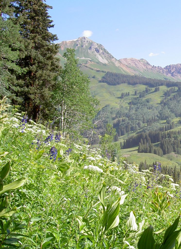
Because of its complexity and often-continuous variation in space, vegetation presents a unique classification challenge. The plants themselves, along with soil, climate, disturbance, and geography, provide useful traits for classifying vegetation. To satisfy different needs of stakeholders for detail, the hierarchical structure of the USNVC provides eight levels of specificity regarding these traits. Just as in the classification system for organisms, there are fewer broadly defined vegetation types in the upper part of the USNVC hierarchy and many more finely defined types in the lower part. Table 1 displays the eight levels of the USNVC for a type of vegetation of the California-Oregon coast in which the Redwood tree is a dominant member of an interacting community of species, dependent on the rainforest climate. At the lowest level of the USNVC hierarchy, called an association, there is a forest of Douglas-fir, Redwood, and Western Swordfern. Vegetation types are catalogued in the USNVC hierarchy from the specific level of the association to the general level of the class, which in this example is ‘Forest & Woodland’.
Utilising vegetation classification in the most efficient and effective way requires a standard classification system for all lands, regardless of the responsible management agency. In the 1990s, the Ecological Society of America (ESA), NatureServe (then part of The Nature Conservancy), and federal land management agencies came together to address a significant need: the creation of a systematic vegetation classification system for the US.
As a result, The United States National Vegetation Classification (USNVC) was born, paired with a data standard describing a protocol for collecting and classifying vegetation data. The USNVC is now the primary standardised classification system for describing all vegetation types in the US. Its use and implementation by various groups helps to foster interagency collaboration and consistent reporting on the nation’s vegetation resources.
Given the rapid pace of scientific discovery in a changing world, flexibility is built into the USNVC, allowing changes to be made as scientists and land managers gather more information. Since its establishment in 1998, the USNVC has been adopted for a variety of applications, including natural resource assessment, wildfire management, and conservation planning.
CREDIT: Pat Comer
Assessing Natural Resources
Classifying vegetation is particularly important for creating reliable vegetation maps and for supporting inventories that quantify the status of vegetation resources. The USNVC is not only important for assessing the status of natural resource conditions (such as timber and biofuels) and ecosystem services (such as water filtration), but also for helping conservation biologists protect habitat for threatened species. Since the 1990s, the US National Park Service (USNPS) has used the USNVC to develop accurate, fine-scale vegetation maps to support natural resource management and conservation in US National Parks. For example, the USNPS recently completed the mapping of the Appalachian Trail, which runs through twelve states, using the USNVC. This consistent standard allowed the USNPS to collaborate effectively with adjoining agencies to support natural resource management in areas that border the Appalachian Trail but are managed by other agencies.
The California Department of Fish and Wildlife used the USNVC to assess the state of the rare Mendocino Cypress Woodlands in California. Land managers within that program mapped existing Mendocino Cypress Woodland stands using the USNVC and then related the presence of the stands to certain soil types known to support the trees. By combining the mapping effort with results of soil surveys and knowledge about species biology, the team determined which areas supported the trees before human settlement. As a result, they estimated that there was a 20 to 44% loss of these sensitive woodlands due to agricultural and human development. This information now helps land managers pinpoint areas where the Mendocino Cypress Woodlands may be declining because of habitat loss, allowing for more directed and effective conservation action revolving around increasing suitable habitat for these rare woodlands.
Finally, the USNVC can also be used to assess the condition of natural resources, including timber. For example, the US Forest Service’s (USFS) Forest Inventory and Analysis Program (FIA) reports and distributes data about forest resources across the US. The FIA has linked its data with the USNVC classification levels, improving the USFS’s ability to monitor the status and condition of both plantation and natural forests, levels of invasive species, stand structure (young forests to old growth), and wood harvesting, by forest type, by region, and across the nation.
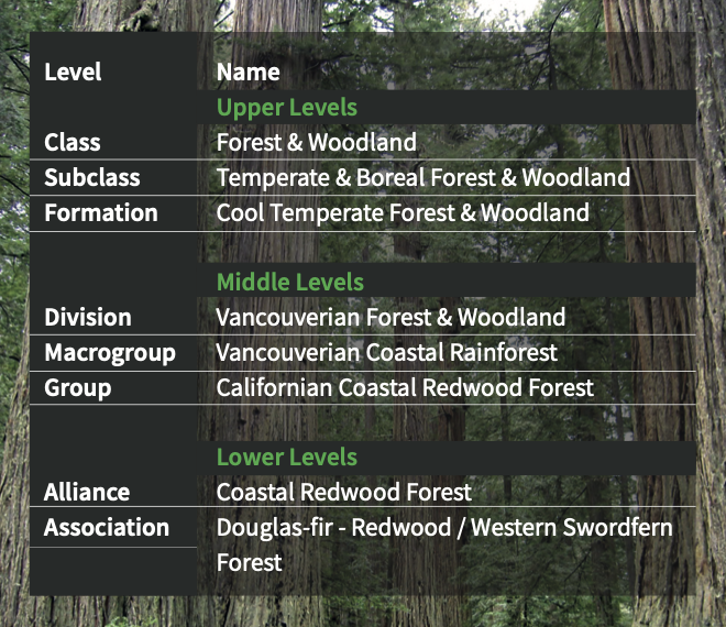
Table 1. USNVC classification hierarchy for the Douglas-fir-Redwood / Western Swordfern Forest illustrated on the cover page of this article.
Fire Management
One of the most successful applications of standardized vegetation-based classification has been in national-scale vegetation mapping in support of wildfire management. In many parts of the US, the wildfire season has grown longer, and the fires have become more destructive and difficult to manage, due to the effects of climate change. Effectively preventing and managing wildfires in these longer, more volatile fire seasons requires a strategic understanding of the status of wildfire fuels, such as dry vegetation.
Since 2002, integrated ecological classifications, including the USNVC, have been critical tools of the LANDFIRE (Landscape Fire and Resource Management Planning Tools) program, a partnership among wildland fire management programs of the US Forest Service and the US Department of the Interior. Other partners include The Nature Conservancy, US Geological Survey, and NatureServe. LANDFIRE produces data that describe existing vegetation types and their structure, biophysical settings, disturbances, seasonal products, wildfire fuels, and fire regimes across the US. One of the main goals of LANDFIRE is to provide agency leaders with the information they need to manage fire risk.
To achieve this goal, LANDFIRE uses a standardized classification approach to define its map legends in support of wildland fire management, allowing for the creation of dynamic models and high-resolution maps. In 2016, the USNVC was included in the LANDFIRE vegetation map in order to further define the map classes. These maps can be used for a variety of ecological and wildfire management applications. For example, by integrating vegetation maps with a database of protected lands of the US, land managers have access to map data that allow them to assess wildfire risk in lands that lie in or adjacent to protected areas, facilitating improved fire-related and landmanagement decisions.

A prescribed fire. CREDIT: Thomas Wentworth.
Conservation Assessment and Planning
Understanding what vegetation types exist and where they occur is essential to planning for the conservation of the organisms that rely on particular vegetation types. In some cases, USNVC map units can be related to habitat suitability for species at risk of extinction. For example, when assessing the status of the federally endangered Salt Marsh Harvest Mouse in the Suisun Marsh of California, researchers needed a better understanding of the habitat requirements of this sensitive species. A research team mapped the habitat of the mice to units of the USNVC and then used this information to track changes in the potential habitat that could support the mice. Over the course of several years, habitat change was monitored to determine if Suisun Marsh was providing less critical habitat for the mice than it had previously.
The USNVC has also been used by federal and state land management agencies to assess how much of a particular vegetation type lies within protected areas. Known as gap analysis, this approach intersects a vegetation map with the boundaries of protected areas to measure the amount of each mapped vegetation type that falls within the current conservation network. In addition to understanding which types are under-represented in the network, this analysis also identifies who owns and manages lands supporting underrepresented types and where there are opportunities for restoration and additional conservation action. This kind of inter-agency collaboration is crucial for assessing progress toward protecting plant communities. It also helps in identifying specific targets for conservation across the US and demonstrates the ability of the USNVC to foster such collaboration to address the nation’s conservation needs.

Salt Marsh Harvest Mice. CREDIT: William Thein.
The Need for an International Standard
Before the creation and implementation of the USNVC, land management groups in the US were classifying vegetation using different standards. However, the geographic distributions of vegetation types are not constrained by agency, state, or country borders.
In the US, streamlined communication among land management agencies is more crucial than ever, necessitating the creation of a federal vegetation classification standard that can be used by anyone.
SHARE
DOWNLOAD E-BOOK
REFERENCE
https://doi.org/10.33548/SCIENTIA784
About the USNVC

CREDIT: Pat Comer.
The United States National Vegetation Classification (USNVC) is the federal standard and only comprehensive vegetation classification system in the US. The USNVC is supported by a formal partnership among the federal agencies, the Ecological Society of America (ESA), and NatureServe, working through the Federal Geographic Data Committee (FGDC) Vegetation Subcommittee. Primary signatories include the US Forest Service, the ESA, NatureServe, and the US Geological Survey Core Science Systems (USGS/CSS).
CONTACT
MEMBERS
NatureServe (NS)
Ecological Society of America (ESA)
US Department of Agriculture (USDA)
• Forest Service (FS) – Chair
• National Agriculture Statistical Service (NASS)
• Natural Resources Conservation Service (NRCS) US Department of Commerce (DOC)
• National Oceanic and Atmospheric Administration (NOAA)
• National Marine Fisheries Service (NMFS) US Department of Defense (DOD)
• US Army Corps of Engineers (USACE) US Department of the Interior (USDI)
• Bureau of Land Management (BLM)
• Fish and Wildlife Service (FWS)
• National Park Service (NPS)
• US Geological Survey (USGS)
Environmental Protection Agency (EPA)
National Aeronautics and Space Administration (NASA)
FURTHER READING
A McKerrow, A Davison, M Rubino, D Faber-Langendoen, D Dockter, Quantifying the representation of plant communities in the protected areas of the U.S.: An analysis based on the U.S. National Vegetation Classification Groups, Forests, 2021, 12, 7, 864.
T Keeler-Wolf, T Hickson, R Yacoub, MJ Colletti, Classification and mapping of Mendocino Cypress (Hesperocyparis pygmaea) Woodland and related vegetation on oligotrophic soils, Mendocino and Sonoma Counties, California, 2019, Classification and Mapping Program, California Department of Fish and Wildlife, Sacramento, CA.
R Boul, D Hickson, T Keeler-Wolf, MJ Colletti, A Ougzin, 2015 vegetation map update for Suisun Marsh, Solano County, California. A report to the California Department of Water Resources, 2018. Prepared by: Vegetation Classification and Mapping Program Biogeographic Data Branch, California Department of Fish & Wildlife.
D Faber-Langendoen, K Baldwin, RK Peet, D Meidinger, E Muldavin, T Keeler-Wolf, J Carmen, The EcoVeg approach in the Americas: U.S., Canadian and International Vegetation Classifications, Phytocoenologia, 2018, 46, 2, 215.
S Franklin, P Comer, J Evens, E Ezcurra, D Faber-Langendoen, J Franklin, M Jennings, C Josse, C Lea, O Loucks, E Muldavin, R Peet, S Ponomarenko, D Roberts, A Solomeshch, T Keeler-Wolf, J Van Kley, A Weakley, A McKerrow, M Burke, C Spurrier, How a national vegetation classification can help ecological research and management, Frontiers in Ecology and the Environment, 2015, 13, 4, 185.
D Faber-Langendoen, T Keeler-Wolf, D Meidinger, D Tart, B Hoagland, C Josse, G Navarro, S Ponomarenko, J-P Saucier, A Weakley, P Comer, EcoVeg: A new approach to vegetation description and classification, Ecological Monographs, 2014, 84, 4, 533.
MD Jennings, D Faber-Langendoen, O Loucks, RK Peet, D Roberts, Standards for associations and alliances of the U.S. National Vegetation Classification, Ecological Monographs, 2009, 79, 2, 173.
FGDC [Federal Geographic Data Committee], Vegetation Classification Standard, FGDC-STD-005, Version 2, Washington, DC, USA, 2008.
REPUBLISH OUR ARTICLES
We encourage all formats of sharing and republishing of our articles. Whether you want to host on your website, publication or blog, we welcome this. Find out more
Creative Commons Licence (CC BY 4.0)
This work is licensed under a Creative Commons Attribution 4.0 International License. 
What does this mean?
Share: You can copy and redistribute the material in any medium or format
Adapt: You can change, and build upon the material for any purpose, even commercially.
Credit: You must give appropriate credit, provide a link to the license, and indicate if changes were made.
SUBSCRIBE NOW
Follow Us
MORE ARTICLES YOU MAY LIKE
Dr Mojtaba Enayati | Turning Trash into Treasure: Recycling PET Waste with Catalysts from PET Labels
Plastic pollution has become a critical environmental problem, with polyethylene terephthalate (PET) plastic widely used in food and beverage packaging being a major contributor. Dr Mojtaba Enayati from Troy University’s Center for Materials and Manufacturing Sciences (CMMS) is leading innovative research aimed at utilising the labels from PET water bottles as an environmentally friendly and cost-effective catalyst for chemically recycling PET waste into valuable monomers and other value-added materials. This innovative work provides an elegant solution for recycling PET by sourcing key components from the PET bottles themselves.

Dr Ottaviano Rüsch | Thermal Cycling and Dust Dynamics: Shaping Rocky Lunar Landscapes
The Moon’s airless surface is constantly bombarded by micrometeoroids, cosmic rays, and extreme temperature swings. These harsh conditions gradually break down rocks and create the fine-grained lunar soil known as regolith. Dr Markus Patzek and Dr Ottaviano Rüsch at the University of Münster are leading a team of researchers (known as the Precious Space Team) who are uncovering new details about how different types of lunar rocks respond to thermal stress and how dust behaves on boulder surfaces. Their work sheds light on the complex processes that shape airless planetary bodies over time.
Dr L Donald Duke | Riding the Storm: How Nature-Based Solutions Can Help Tackle Flooding in Southwest Florida
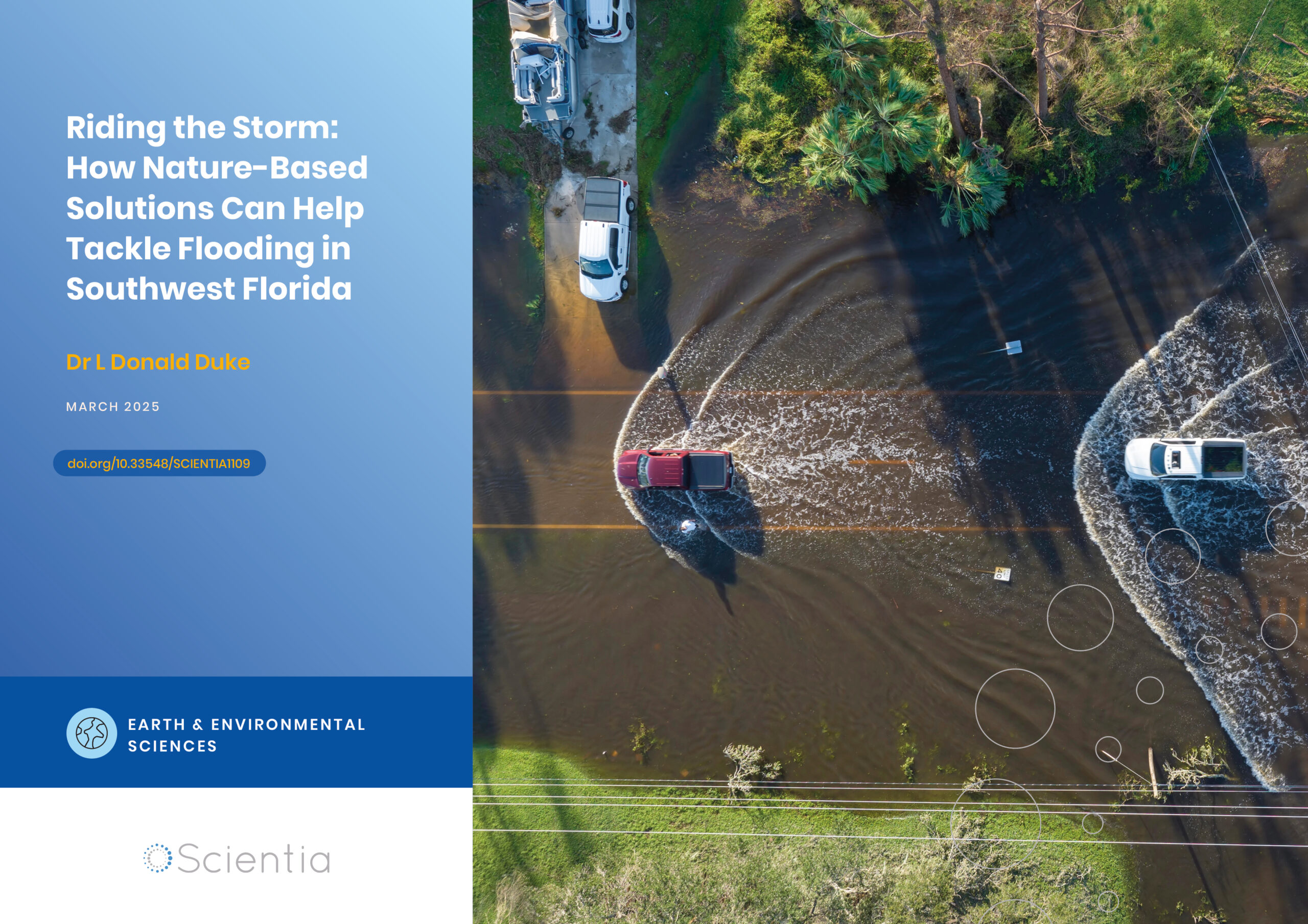
Florida grapples with mounting challenges related to inland flooding due to heavy precipitation, along with coastal flooding from rising sea levels and coastal storms. One important approach to address precipitation-originating flooding is to embrace land use practices runoff management in the upstream portions of at-risk watersheds, where sustainable design can relieve the pressures on drainage systems from continuing dense urban development in the low-lying Florida landscape. Dr L Donald Duke, from The Water School at Florida Gulf Coast University, plays a pivotal role in this endeavour. His work encompasses creating and evaluating flood-resilient land use practices and planning to manage stormwater runoff on the watershed scale.

Improving Food Safety of Hydroponic Leafy Greens
Hydroponic farming is experiencing rapid growth worldwide, offering a sustainable and efficient method of producing fresh, nutrient-rich crops. However, the unique conditions of hydroponic systems also present complex food safety challenges. Dr Sanja Ilic and Dr Melanie Lewis Ivey, researchers at The Ohio State University, are at the forefront of efforts to understand and mitigate the risks of human pathogen contamination in commercial hydroponic production. Their pioneering work is providing crucial insights and practical guidance to help ensure the safety and nutritional value of hydroponically grown leafy greens.